Week of 5/5 - 5/9
- kaurmanji0719
- May 8, 2025
- 3 min read
This week, Mr. Christy had a project he wanted completed by some students. Kim, Bella, and I volunteered for the project. Mr. Christy asked us to decorate and label a map of the combined walking distance he has traveled to get to school with some other teachers. This distance, combined, stretched from Medford all the way to Albany, NY. We had to label the following places: Massachusetts, Vermont, New Hampshire, and New York along with many cities like Medford, Worcester, Pittsfield, Marlborough, Syracuse, NY, and many others.
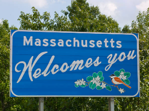
On Monday, Kim and I started the project by outlining the borders of all the states to make them more defined on the map, and we placed markers on the map of the cities we had to label so they would be more prominent. We then began brainstorming ideas of what we wanted the city signs to look like. At first, we thought about replicating "Welcome to..." signs in the various states as the sign markings for all of the states we included. We attempted a few designs for these signs and found it difficult to make them look right or accurate to the actual signs in photos. We then thought about using the license plates of the various states, but ran into the same issue of difficult designs. We decided to make completely original designs using things that are valuable to the respective states and designing the signs so they accurately represented the states we labeled.

On Tuesday, we began creating the signs for the states with Bella. The initial designs for the signs were very rough, and it took multiple tries for us to get the signs to look the way we wanted them to. In the end, though, we were able to create unique, original designs for all of the state signs that represented the states accurately. We got the general designs of the signs down, and we waited until Thursday to complete the minor details in the signs with markers Kim was able to bring in from home.

On Wednesday, we continued to work on the signs for the map, as we needed to create signs for the various cities that we had to label. Kim had the idea of making the signs look like quotation boxes with a pointing arrow at the top or bottom of the sign for the city. This arrow points directly to where the city is. We used this design to create a unified theme for the city signs, and we decided to do a similar thing with the city signs as with the state signs; we researched things that were meaningful to the cities and drew them on the signs, labelling them.

On Thursday, we were able to finish the designs for the state signs with the markers Kim brought in from home. After this, we began to glue the signs down onto the map. The issue we ran into here was that the glue caused the ink from the markers to run when we put the glue on top of it. We were able to make do with this issue by finding ways to glue the signs without going over the actual designs too much. Mr. Christy told us to stop gluing if the glue caused the designs to bleed, so that our designs would not be ruined. On Friday, we will find a new method to glue the signs onto the map in a way that would preserve the designs.


Comments